Homs situated in between the desert from the East and the gateway of sea from the West, located in a wide area of plain and fertile area forming an important point of communications in Syria and its neighboring countries, thus the commercial roads from Damascus to Aleppo passes via Homs, and from the Desert to the Mediterranean Sea and thus it is connected to the sea by a broad valley easy to cross through.
Homs occupies a prominent place in the history ofSyria due to its distinguished position and due to events where it played a remarkable turn right throughout history due to its geographical situation and now it becomes the main pole of Syrian economic and its building and social developments.
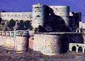
Standing as high as 2300 feet above sea level stands what is much considered the greatest fortress in the world, Krak Des Chevaliers (Castle of the Knights). With its command over the valley betweenHoms and Tripoli, and being a model of perfection of medieval fortification, this Castle was never besieged or taken by storm. It only fell through Baibars unique plan involving trickery.
The history of this magnificent fortress is not very well known, it was given to a Kurdish garrison by the Amir ofAleppo in 1031. This has been proven through Muslim chronicles, which named it Castle of the Kurds (Hisn Al Akrad). The castle that the Kurds erected was taken over by the Count of Toulouse in 1099 and then by the Latin prince Tancred in 1110. It was taken over by the Hospitallers in 1142, for the defense against the threat of Zengi inAleppo. After that the Krak was kept in the hands of the crusaders, although it was damaged by a couple of earthquakes, and was rebuilt in its final form in the 13th century. It only fell to the Mameluke Sultan Baibars who resorted to a trick in which he forged a letter supposedly from the Crusader commander in Tripoli that said that they should surrender, and so the greatest fortress in the world fell.
This monastery has two chapels; one was built in the 13th century and contains an iconostasis in ebony wood, while the other was built in 1857. The convent contains the shrine of St. George, which was built in the 5th century. It also contains a copy of a document written by Caliph Omar Ibn Al Khattab dating back to the 14th year after the Hegirah (Mohammad's (P) immigration from Mecca to Medinah in 615 AD, which is the starting year of the Islamic lunar calendar). The convent contains many beautiful icons dating far back.
Al Hir Al Sharki (Eastern):
Located approximately 120 Km east ofPalmyra. This Castle's grounds actually consist of two separate castles, which are situated 43 meters apart, a large garden area and a small village.
Although there is much speculation as to what this castle's purpose was for, the most probable theory is that it was the site of a large agricultural settlement, with some defensive purpose against some of the desert tribes and the threat of Mesopotamia. It seems at first sight to have some Byzantine or Roman origin; although most believe that the Roman capitals were taken from nearby sites or were carved by Christian craftsmen. It was most probably built in the 700s under the Umayyad Caliph Hisham. After the Umayyads were overturned the Abbassids found some use in keeping it flourishing (by then it had become a center for controlling caravan traffic, hence commercial wealth), however only on a small scale. It was later resettled in the 11th century till the 13th and with the Mongol invasion was abandoned.
The Castle grounds were surrounded by a mud brick wall, which can still be seen at some points. You can also see very little of the garden area and the village. As for the two castle buildings, their gateways face each other at a distance of 43 meters and have a minaret in between; this minaret could be the third oldest minaret in Islam. The gateways are well designed with a mixture of Byzantine, Arab and Mesopotamian architecture and have on both sides' large cylindrical towers. The smaller eastern half of the couple is the most beautiful feature of this site. The western castle is by far the larger of the two and has a large area for habitation. There are also some remains of baths to the north of the site.Qasr Al Hir Al Gharbi (Western):
This castle, located 80 Km away from Palmyra on theDamascus road. Built by the Umayyad Caliph Hisham Bin Abd Al Malik in 727 AD, this site used to be a Byzantine one.
It was used as an outpost toDamascus, to keep eye on the Desert tribes and defensive arrangements as well as being a hunting lodge. It was used by the Ayyubids and the Mamelukes but was deserted permanently after the Mongol invasions.
The castle itself is square in shape with 70-meter sides. The central gateway to this castle is very beautiful, and has been moved to be used as the entrance to the National museum inDamascus. With its semi-cylindrical towers on the sides of the gateway, pillars, and the geometric shapes, it reflected a mixture of Persian, Byzantine and Arab architecture.Taken from:
http://www.syriagate.com/Syria/about/cities/Homs
http://www.middleeast.com/homs.htm http://www.made-in-syria.com/homs.htm
 The Girdle Of Our Lady Virgin Mary
Homs occupies a prominent place in the history ofSyria due to its distinguished position and due to events where it played a remarkable turn right throughout history due to its geographical situation and now it becomes the main pole of Syrian economic and its building and social developments.
History of Homs
 |
Homs is an ancient town, its history goes back to about 2300 years B.C. and it was according to historical records established in Calcium Stone Age later on extended to become a town as a state governed by priests in the third century B.C.
There was a famous temple in Homs for worshiping sun likewise BaalbeckTemple mentioned more than once in the Bible.
This city was known in Roman times as the city ofEmesa and had strong connections with the Severid Dynasty. Julia Domna the daughter of a high priest of Emesa married Septimius Severus, while he was stationed here. He later became emperor of Rome. When he was transferred to Rome Julia took over and was a principal figure in the dynasty's fortunes. Emesa's fortunes were always tied with the trade city ofPalmyra. As long asPalmyra flourished so did Emesa. When Zenobia was defeated atPalmyra in about 272 AD, Emesa declined.
Christianity established itself in Emesa early on, as 3rd to 7th century catacombs were found in houses in the eastern quarter, where quite a large population of Christians still live. After Arab conquest, it is said that 500 of the prophet's companions came and settled here. Homs became important, again but by the 18th century Homs had sunk into a state of weakness.
Historical Sites of Homs
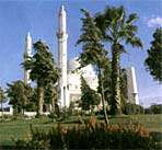
Great Mosque of Al Nuri
This mosque is said to stand on the site of the Temple of Baal, and a later Church of St. John. The columns used in this mosque are of the oldest objects in this city.Mosque of Khaled Ibn Al-Walid
 |
The construction of this ancient mosque was solid with huge foundations and solid knots ceiling from the remnant of King Daher Perbars. But the recent building goes back to the Ottoman days during the regime of Sultan Abdul-Hamid II. And been mentioned that Nazem Pasha, one of Damascus governors in the regime of Abdul-Hamid obtained 6000 Ottoman Dinars, whole of it spent as the cost ornaments which been on the tomb. Destroyed the old building completely and constructed the new mosque on the pattern of Constantine Mosque, and completed same in year 1331.
Church of Umm Al Zunnar (the Virgin's Girdle)
In 1953 a textile belt was found here under the altar, it is said to have belonged to the Virgin Mary. The current building only dates back to the 19th century but a 4th Century Church used to be on this site and it is believed that the textile belt was placed here.Church of St. Elias (Mar Elian)
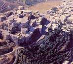
In 1970 a collection of fine murals were discovered in the crypt beneath a coat of plaster. This church dates back to the 6th Century AD and was built in dedication to the son of a Roman officer who was martyred in the 3rd century for refusing to renounce Christianity.The Citadel
Little remains of this citadel, which was destroyed in the 1830s by Ibrahim Pasha. It is located in the southwestern part of the city, on a natural mound surrounded by a moat. The mound is now off-limits. This citadel played an important role in the history ofHoms especially under the Nourite, Ayyubite, and Mameluke states, the Ayyubites in particular.Souks of Homs
The souks of Homs are located in the ancient part of the city and occupy a large area. Most parts of the souk were constructed during the Ayyubite, Mameluke, and Ottoman periods. Outskirt of Homs
Krak Des Chevaliers (Qalaat Al Husn)
 |
The history of this magnificent fortress is not very well known, it was given to a Kurdish garrison by the Amir ofAleppo in 1031. This has been proven through Muslim chronicles, which named it Castle of the Kurds (Hisn Al Akrad). The castle that the Kurds erected was taken over by the Count of Toulouse in 1099 and then by the Latin prince Tancred in 1110. It was taken over by the Hospitallers in 1142, for the defense against the threat of Zengi inAleppo. After that the Krak was kept in the hands of the crusaders, although it was damaged by a couple of earthquakes, and was rebuilt in its final form in the 13th century. It only fell to the Mameluke Sultan Baibars who resorted to a trick in which he forged a letter supposedly from the Crusader commander in Tripoli that said that they should surrender, and so the greatest fortress in the world fell.
St. George's Convent
(Deir Mar Jurjus)
This area is called Valley of the Christians, and has been a center for the Greek Orthodox sect since the beginning of Christianity.St. George's convent/monastery was built by hermits in the late 5th century AD (although some say in the 6th century AD under the Emperor Justinian). However, parts of the convent were built in the 18th, 19th and 20th centuries.This monastery has two chapels; one was built in the 13th century and contains an iconostasis in ebony wood, while the other was built in 1857. The convent contains the shrine of St. George, which was built in the 5th century. It also contains a copy of a document written by Caliph Omar Ibn Al Khattab dating back to the 14th year after the Hegirah (Mohammad's (P) immigration from Mecca to Medinah in 615 AD, which is the starting year of the Islamic lunar calendar). The convent contains many beautiful icons dating far back.
Qasr Al Hir
Often called the Desert palaces there are two, Qasr Al Hir Al Sharki (Eastern) and Qasr Al Hir Al Gharbi (Western).Al Hir Al Sharki (Eastern):
Located approximately 120 Km east ofPalmyra. This Castle's grounds actually consist of two separate castles, which are situated 43 meters apart, a large garden area and a small village.
Although there is much speculation as to what this castle's purpose was for, the most probable theory is that it was the site of a large agricultural settlement, with some defensive purpose against some of the desert tribes and the threat of Mesopotamia. It seems at first sight to have some Byzantine or Roman origin; although most believe that the Roman capitals were taken from nearby sites or were carved by Christian craftsmen. It was most probably built in the 700s under the Umayyad Caliph Hisham. After the Umayyads were overturned the Abbassids found some use in keeping it flourishing (by then it had become a center for controlling caravan traffic, hence commercial wealth), however only on a small scale. It was later resettled in the 11th century till the 13th and with the Mongol invasion was abandoned.
The Castle grounds were surrounded by a mud brick wall, which can still be seen at some points. You can also see very little of the garden area and the village. As for the two castle buildings, their gateways face each other at a distance of 43 meters and have a minaret in between; this minaret could be the third oldest minaret in Islam. The gateways are well designed with a mixture of Byzantine, Arab and Mesopotamian architecture and have on both sides' large cylindrical towers. The smaller eastern half of the couple is the most beautiful feature of this site. The western castle is by far the larger of the two and has a large area for habitation. There are also some remains of baths to the north of the site.Qasr Al Hir Al Gharbi (Western):
This castle, located 80 Km away from Palmyra on theDamascus road. Built by the Umayyad Caliph Hisham Bin Abd Al Malik in 727 AD, this site used to be a Byzantine one.
It was used as an outpost toDamascus, to keep eye on the Desert tribes and defensive arrangements as well as being a hunting lodge. It was used by the Ayyubids and the Mamelukes but was deserted permanently after the Mongol invasions.
The castle itself is square in shape with 70-meter sides. The central gateway to this castle is very beautiful, and has been moved to be used as the entrance to the National museum inDamascus. With its semi-cylindrical towers on the sides of the gateway, pillars, and the geometric shapes, it reflected a mixture of Persian, Byzantine and Arab architecture.Taken from:
http://www.syriagate.com/Syria/about/cities/Homs
http://www.middleeast.com/homs.htm http://www.made-in-syria.com/homs.htm
The Girdle Of Our Lady Virgin Mary
No comments:
Post a Comment